From The Doc Searls Weblog: "Storm of Light. 
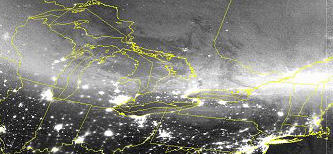
NASA's October 2003 Aurora Gallery has some amazing photographs of the aurora show that the current series of solar storms has been putting on. Here's a shot from the USAF Defense Meteorological Satellite Program that shows auroras that are not only brighter than the city lights below them, but blurring the city images as well. If you look at the yellow outlines of state, provincial and Great Lake boundaries, you'll see that the brightest auroras ran in a line from Southern Quebec and Ontario through Michigan, Wisconsin, Minnesota and South Dakota ó right over the cities of Quebec, Montreal, Toronto, Detroit, Milwaukee and Sioux Falls. That was at 0214 UTC on 30 October, or 9:14pm, EST in the U.S. and Canada on 29 October. In other words, the night before last. Since auroras run up to 800 miles high, they are visible up to 1000 miles away or more. Which is why we have sightings as far south as Florida and Texas. Though subsiding, the latest storm is still going on (as of dawn here in Santa Barbara). According to the NOAA POES Auroral Activity Map, there is still intense activity where it's still dark: over the Northern and Yukon Territories of Canada, nearly all of Alaska, the entire northern border of Russia, and the southern reaches of New Zealand and Australia. NASA has a terrific page on Space Weather that includes photos of auroras from space and 9MB movie titled Animiation of CME impact on Earth's magnetosphere. A great watch if you have the bandwidth." [The Doc Searls Weblog]
1:30:59 PM 
|
|
